


US Braces for Coastal Flooding, Extreme Surf as Hurricane Erin Approaches.
The entire Eastern Seaboard of the United States is on high alert as Hurricane Erin accelerates toward the coast, threatening to unleash devastating storm surge, towering waves, and prolonged flooding from Florida’s Panhandle through the mid-Atlantic and up to New Jersey.
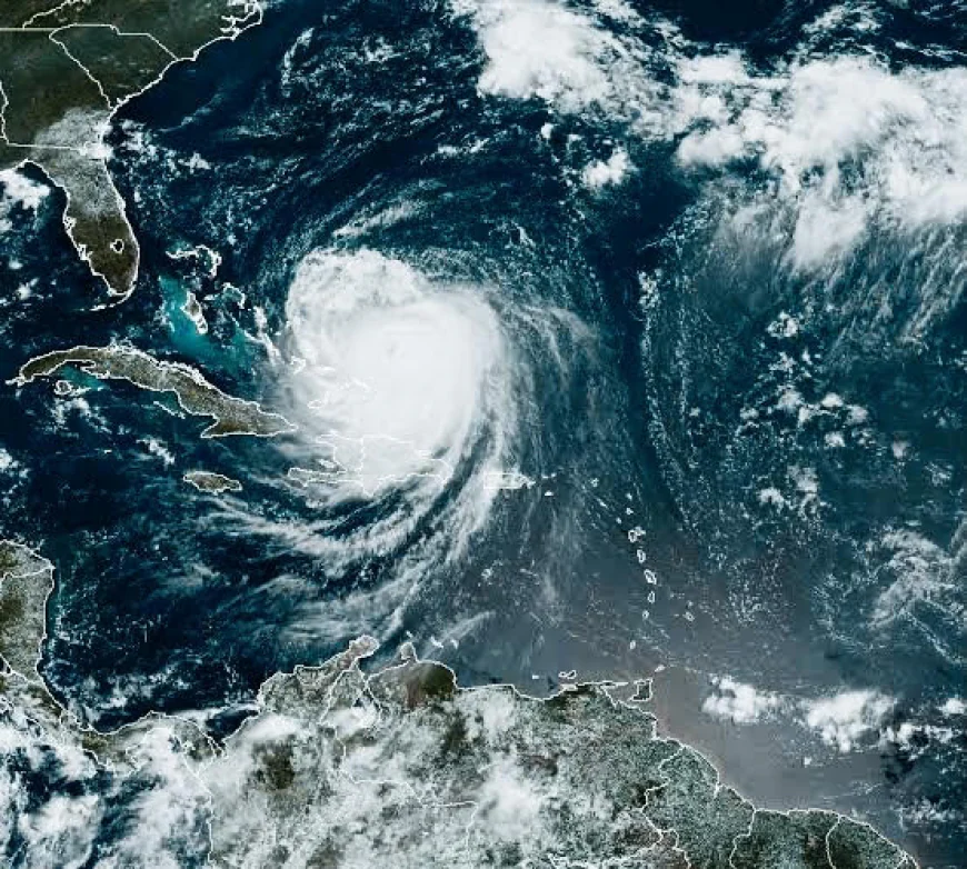
Hurricane Erin rapidly intensified overnight from a Category 2 to a Category 4 storm, with maximum sustained winds currently recorded at 140 mph and gusts exceeding 165 mph. Forecasters at the National Hurricane Center (NHC) report that Erin is now one of the most powerful storms of the season, continuing to strengthen as it moves northwestward at 18 mph over some of the warmest stretches of the western Atlantic.
The storm’s massive wind field extends hundreds of miles across, creating extensive swells that are already increasing wave heights miles offshore. Erin is expected to make landfall late Tuesday night or early Wednesday along the Carolina coastline, with a wide area expected to feel hurricane force winds and dangerous surge levels.
The greatest threat to human life and property is forecast to come from the lethal combination of storm surge and battering waves. Ocean buoy measurements recorded waves up to 25 feet high well offshore, with projections estimating near shore wave heights could reach between 20 and 30 feet during peak surge times.
Coastal communities in low-lying areas can expect significant inundation, with some regions anticipating storm surge flooding reaching up to 15 feet above normal tide levels. This means many barrier islands, seaside neighbourhoods, and flood plains will be underwater for several hours or even days as floodwaters become trapped behind natural coastal defenses.
Emergency management experts warn this surge and wave action will erode protective sand dunes and seawalls, destroy homes and infrastructure, and contaminate freshwater systems with seawater flooding. The high waves pose immediate risks of drowning, structural collapse, and dangerous debris being hurled inland.
-Florida Panhandle: Areas including Pensacola and Panama City have been under mandatory evacuation orders since Sunday, with residents urged to seek safety inland. Coastal roads are being closed, and emergency shelters have reached capacity.
-Georgia and South Carolina: Charleston has declared a state of emergency, ordering evacuations for low-lying coastal neighborhoods and barrier islands. Authorities warn of both flooding and downed power lines.
-North Carolina and Virginia: Wilmington, Norfolk, and surrounding communities braces for flooding, power outages, and travel disruptions. Evacuations are in effect for coastal counties, with emergency officials warning of flash floods inland as well.
-Mid-Atlantic (Maryland, Delaware, New Jersey): While the storm is expected to weaken slightly, dangerous waves and flooding are still projected, with tidal flooding compounded by usual high tides producing what experts call “a historic coastal flooding event.”
State and local governments are coordinating to provide resources, including high-water vehicles, heavy equipment for debris clearing, and medical response teams prepared to deal with injuries and emergencies. Power companies report staging additional crews in key locations to address expected widespread outages as fallen trees and flooding damage transmission lines.
FEMA has pre-positioned supplies such as water, food, generators, and temporary shelter materials in strategic regions expected to be hardest hit.
Additionally, the Coast Guard has issued warnings forbidding all recreational and commercial vessels from leaving port, with ongoing search and rescue missions for mariners caught off-guard.
Officials stress that individuals must not underestimate the danger posed by the waves both onshore and offshore. Rip currents generated by the hurricane extend hundreds of miles and have already caused multiple rescues along southern beaches.
Residents are advised to:
- Follow all evacuation orders immediately
- Avoid travel in flood-prone areas
- Secure boats and outdoor possessions
- Prepare for power outages with emergency kits including water, medications, and batteries
- Stay tuned to official updates via NOAA Weather Radio, local news, and emergency management channels
Dr. Emily Hernandez, a leading meteorologist with the NHC, warned, “Storm surge and high waves are the deadliest elements of hurricanes like Erin. Even when the winds die down, the water will continue to cause dangerous conditions for days. Please take all safety precautions seriously.”
As Hurricane Erin barrels toward the US East Coast, communities are urged to prepare for what experts say will be one of the most severe coastal storms in recent memory. The storm is expected to weaken as it moves inland but could still bring heavy rain and flooding as far north as New England over the coming days.
Emergency officials continue to monitor conditions closely and urge residents to remain vigilant and heed all warnings to minimize loss of life and property.